
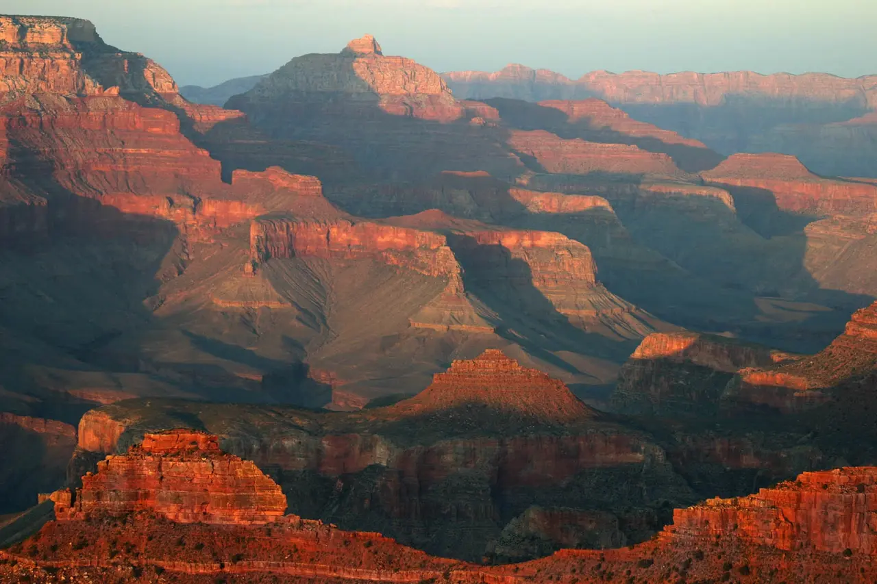
The Grand Canyon is not one interchangeable destination. The South Rim, North Rim, inner canyon, Colorado River, and Grand Canyon West use different roads, services, tickets, physical demands, and time plans.
For many first-time visitors, the South Rim is the practical default. It combines broad viewpoints, visitor services, shuttle routes, and walks that can be adjusted to the day. That does not make every South Rim road, trail, water point, or building continuously available.
Choose the exact area before booking accommodation or a tour. Then let current alerts control the route. A rim-to-river hike is a serious backcountry undertaking, not a normal extension of a sightseeing day.
Table of contentsJump to a section
Quick answer
Start with the current NPS conditions page. A saved itinerary should never override an active closure or heat warning.
Choose the right Grand Canyon area
The right choice depends on your starting point, season, mobility, and the experience you actually want.
South Rim
Best for: major viewpoints, the broadest visitor services, shuttle connections, and adjustable rim walks.
Access: generally open year-round, with local road, trail, water, and service closures still possible.
Choose it when: you want the most straightforward national-park introduction.
North Rim
Best for: a higher, quieter rim experience when the specific road, campground, trail, and service plan works.
Access: a long separate road approach with seasonal operations and current post-fire recovery limits.
Choose it when: the dated NPS status page supports the complete route, not because a generic annual calendar says it should be open.
Grand Canyon West
Best for: some Las Vegas-based trips and travelers specifically interested in Hualapai-operated experiences such as the Skywalk.
Access: on Hualapai lands outside Grand Canyon National Park, with separate tickets and rules.
Choose it when: this is the experience you want, rather than treating it as an unnamed substitute for the South Rim.
Inner canyon and Colorado River
Best for: prepared hikers, permitted backcountry plans, mule trips, or authorized river travel.
Access: major elevation change, heat, limited water, and activity-specific permits or reservations.
Choose it when: you can plan it independently from an ordinary rim sightseeing day.

North Rim status checked August 5, 2026
Read the current North Rim status page before committing accommodation, fuel, or a long approach drive. The South and North Rims are not connected by a short road across the canyon.
How many days at the Grand Canyon
Half a day
A half-day can provide a few South Rim viewpoints and a short rim walk, but much of the time may disappear into arrival, parking, orientation, and shuttle movement. It is a limited overview, not a complete visit.
One full day
One full South Rim day is a useful minimum. It can include a visitor-information stop, a small sequence of connected viewpoints, a Rim Trail section, and either Desert View or a modest below-rim walk.
Two nights
Two nights are a stronger default because they provide one full day at the rim plus flexibility for weather, sunset transport, a shuttle queue, and a conservative hike. Staying near the chosen rim also avoids beginning and ending the main day with the longest drive.
North Rim travel, rim-to-rim hiking, overnight backcountry use, and river trips need separate schedules. Do not apply a South Rim sightseeing estimate to them.
A practical South Rim first day
- Check current operations. Confirm the entrance road, parking, shuttles, weather, water, and trail notices before leaving accommodation.
- Orient at a staffed information point or major viewpoint. Ask about the route that is realistic that day.
- Use a few connected viewpoints. Let walking and the current shuttle replace repeated parking where practical.
- Add a Rim Trail section. Choose the distance and surface that suit the group.
- Make one afternoon decision. Take a conservative below-rim walk, continue along the rim, or use Desert View Drive when road and daylight allow.
- Plan the return before sunset. Know the last practical shuttle or walking route and carry a light and layers.
The goal is not to collect every viewpoint name. Time spent watching light and weather move across the canyon is part of the visit.
One-day and two-day route options
Keep these route shapes flexible. Current NPS operations should decide the final order.
Central South Rim plus one branch
Core: orientation, a few central viewpoints, and a suitable Rim Trail section.
Choose one: a modest below-rim walk, Hermit Road viewpoints using the current shuttle plan, or Desert View.
Protect: water, meal, weather, and sunset-return time.
Split the rim into coherent areas
Day 1: Grand Canyon Village, central viewpoints, and the current Hermit Road plan.
Day 2: Desert View and geology or cultural interpretation, with a modest hike only if conditions suit.
Benefit: more room for weather, shuttle queues, and a conservative turnaround.
Choose the right South Rim entrance
The South Rim has two public road entrances. Select the entrance from the wider Arizona route before arranging accommodation or copying a navigation result. The two entrances reach different ends of the same rim corridor.
South Entrance
This is the usual approach for travelers arriving through Williams, Tusayan, Phoenix, Las Vegas, or the western side of Flagstaff.
It reaches the central visitor-center and village area first. Busy periods can create entrance and parking queues, so review the current Tusayan park-and-ride option.
East Entrance at Desert View
This approach can fit travelers arriving through Cameron, Page, or the eastern side of Flagstaff when the current road route is open.
It reaches Desert View before Grand Canyon Village. Treat the scenic drive between them as a meaningful part of the day, not an instant connection.
Check the official South Rim directions and current road conditions before departure. A route app does not confirm snow, incident, fire, construction, or entrance status.
South Rim shuttle planning
The South Rim shuttle network reduces some parking pressure and connects useful walking sections, but its routes and road restrictions change by season. Use the current NPS map rather than memorizing an article schedule.
Plan for queues at busy stops. Weather, traffic, incidents, or operational problems can interrupt service. Some roads also restrict private vehicles during parts of the year, so arriving with a car does not guarantee direct access to every viewpoint.
As checked August 5, the 2026 summer plan includes a Tusayan park-and-ride route through September 11. Riders need a valid park pass, and the route does not operate year-round. Confirm the current Tusayan shuttle status before relying on it for entry or the return to accommodation.
NPS shuttle buses are wheelchair accessible within published size and weight limits. A Scenic Drive Accessibility Permit can provide access to certain roads otherwise closed to private vehicles when current rules and individual needs apply.
Review the official South Rim shuttle page on the day of use. Build a walking fallback only if its surface, distance, light, and weather suit the group.
Short walks and hikes
Rim Trail
The Rim Trail is the best default for many first-time visitors. It can be shortened or extended, connects with shuttle stops, and includes some paved and accessible sections. Not every segment has the same surface, grade, exposure, or winter condition, so choose a specific section rather than assuming the entire rim is equivalent.
Bright Angel Trail
Bright Angel descends steeply below the rim, and the return climb is the harder half. Water availability is seasonal and can be interrupted by pipeline failures. Winter ice can make the upper trail hazardous. Set a conservative turnaround based on the weakest prepared person, current heat or ice, and the water you actually carry.
South Kaibab Trail
South Kaibab is steep, exposed, and has no water on the trail. Access normally depends on the current shuttle arrangement rather than trailhead parking. A short descent can still become dangerous in heat, wind, ice, or when a visitor underestimates the climb back.
Do not promote Hermit or Grandview trails as casual beginner alternatives. They have different route-finding, water, maintenance, and exposure considerations. The NPS day-hiking page should control any below-rim plan.
Grand Canyon hiking safety
Build every hike around these realities:
- Inner-canyon temperatures can be far hotter than conditions at the rim.
- High rim elevation can affect breathing, pace, and recovery.
- Water taps can be seasonal, shut down, or affected by pipeline failures.
- Shade is limited on exposed routes.
- Winter snow and ice can require traction and a shorter plan.
- Thunderstorms, flash flooding, smoke, and high winds can alter access and visibility.
- Rescue is not a substitute for a conservative route and turnaround.
Carry enough water and food for the actual route, know where verified water is available, and turn around before the group is tired. Read the official hiking FAQ rather than choosing a descent from social-media footage.
Sunrise, sunset and photography
Sunrise can simplify the return because daylight follows, though cold, ice, and an early drive still matter. Sunset brings changing light but also crowds, falling temperatures, darkness, and pressure on parking or shuttles.
Choose a viewpoint with a known return route. Carry a headlamp, layers, and offline directions. Stay behind barriers and away from unstable edges; a photograph is not a reason to step beyond a designated area. Smoke, cloud, dust, or storms may obscure the view, so do not promise the trip around one perfect sunset.
Where to stay and road approaches
Accommodation choice determines how much of the first and last day becomes driving. Check the exact property, entrance, and seasonal road route.
Inside the South Rim park area
Advantage: simpler early and late access with less daily approach driving.
Trade-off: availability is limited, and lodging or camping reservations are separate from park entry.
Tusayan
Advantage: close to the South Entrance with food and accommodation choices.
Trade-off: entrance traffic and seasonal transport arrangements still affect the day.
Williams
Advantage: useful for travelers combining a road approach or Grand Canyon Railway plan.
Trade-off: it adds a meaningful approach compared with sleeping near the rim.
Flagstaff
Advantage: more accommodation, food, and onward-route flexibility.
Trade-off: the park day starts and ends with a longer drive.
Sedona
Advantage: it works in a broader Arizona route.
Trade-off: Sedona deserves its own time; avoid treating the canyon as a rushed side trip.
Las Vegas
Advantage: many organized trips depart from the city.
Trade-off: listings may visit Grand Canyon West rather than the South Rim, and a long day can contain substantial vehicle time.
North Rim gateways
Advantage: they place you near the chosen northern approach when current operations support it.
Trade-off: there is no in-park North Rim lodging in 2026, and limited services require careful fuel, food, water, and road planning.
Avoid a long canyon drive immediately before a non-refundable flight. The road between areas bears little relationship to the distance visible across the canyon.
Fees, passes and reservations
Grand Canyon National Park charges an entrance fee or accepts qualifying federal recreation passes. There is currently no general timed-entry reservation for ordinary park access, but a pass does not reserve accommodation, camping, a tour, a mule trip, a river trip, or backcountry use.
Specific activities may require permits or advance reservations. Grand Canyon West has separate Hualapai-operated admission and is not covered by the national-park entrance arrangement. Confirm the exact destination and product before paying.
Use the current NPS fees and passes page instead of an old price table.
Grand Canyon accessibility
Accessibility varies by viewpoint, path, building, shuttle stop, weather, and surface condition. Some South Rim viewpoints and Rim Trail sections are accessible. NPS shuttle buses are accessible within stated equipment limits, and the Scenic Drive Accessibility Permit can help eligible visitors reach certain restricted-road areas.
The whole park is not wheelchair accessible, and a paved overlook does not mean the connecting path or restroom is currently available. Review the NPS accessibility guide, then confirm the exact stops you plan to use.
A living cultural landscape
Grand Canyon is not only a geological spectacle or a stage for explorer stories. The NPS identifies 11 associated Tribal nations with ancestral and continuing relationships to the canyon. Communities maintain cultural, spiritual, historical, and practical connections to the land and water today.
Use Tribal and NPS interpretation, respect closures and culturally sensitive places, and do not remove objects or enter archaeological sites. Place names and exhibits may reflect ongoing work to correct older narratives.
Grand Canyon West is operated by the Hualapai Tribe on Hualapai lands. That ownership and cultural context are central, not a small ticketing difference. Consult the NPS associated-Tribes overview and the official Grand Canyon West site.
What to skip
- Skip trying to visit the South and North Rims in one day.
- Skip a rim-to-river-and-back day hike.
- Skip collecting every viewpoint at the expense of time at the rim.
- Skip booking a product called only “Grand Canyon” without checking the exact area.
- Skip sunset when you do not have a safe return and transport plan.
- Skip assuming a shuttle route or water tap always operates.
- Skip a long canyon drive immediately before a flight.
- Skip cliff-edge photographs outside designated public areas.
Grand Canyon tour options
A guided South Rim trip can reduce driving from some Arizona bases and from Las Vegas, but the destination must be explicit. The article remains complete without loading this optional widget.
Check whether a listing visits Grand Canyon National Park’s South Rim or Grand Canyon West, how long it stays at viewpoints, its pickup and return plan, accessibility, meals, park admission, and cancellation terms.
Affiliate note: WeltFox may earn a commission from an eligible booking through this tool at no additional cost to you. The provider controls availability, prices, and booking terms.
Official Grand Canyon planning links
Use the National Park Service for the details most likely to change. Reopen the relevant pages shortly before travel rather than relying on a saved version of this guide.
Grand Canyon checklist
- Name the exact area: South Rim, North Rim, Grand Canyon West, or inner canyon.
- Open current NPS alerts and road conditions.
- Confirm the entrance and accommodation route.
- Download the current shuttle map.
- Check trail and water status.
- Review heat, storm, smoke, and winter-ice conditions.
- Carry suitable water, food, footwear, sun protection, and layers.
- Set a conservative route and turnaround.
- Save an offline map and emergency information.
- Arrange sunset return transport before dark.
FAQ
Grand Canyon planning FAQ
Which rim is best for a first Grand Canyon visit?
The South Rim is the practical default for many first-time visitors because it combines major viewpoints, visitor services, shuttles, and adjustable walks. Current operations, starting point, mobility, and season should still decide the trip.
Is one day enough for the Grand Canyon?
One full South Rim day can cover a few connected viewpoints, a Rim Trail section, and one additional branch. Two nights are a stronger plan because they provide a full day plus weather, shuttle, and sunset flexibility.
Can you visit the South Rim and North Rim in one day?
No practical road crosses the canyon between them. The drive is long, and current North Rim access is limited and seasonal. Choose one rim rather than spending the day in transit.
Is Grand Canyon West part of Grand Canyon National Park?
No. Grand Canyon West is operated by the Hualapai Tribe on Hualapai lands outside the national park. It has separate tickets, rules, and experiences and should not be confused with the South Rim.
Can you hike to the Colorado River and back in one day?
The National Park Service advises against a rim-to-river-and-back day hike, especially in hot months. Heat, elevation change, limited water, and the return climb make it far more serious than a normal day walk.
Do you need a reservation to enter Grand Canyon National Park?
There is currently no general timed-entry reservation for ordinary park access, but an entrance pass is required. Lodging, camping, backcountry use, tours, mule trips, and river activities can have separate reservations or permits.
Are Grand Canyon South Rim shuttles free?
No separate fare is collected for the park shuttle; service is included with park entrance. Routes and road restrictions change by season, and weather or operations can interrupt service, so use the current NPS map.
Is the Grand Canyon North Rim open in 2026?
Yes, but with important limits. As checked August 5, 2026, all paved North Rim roads, the campground, and the North Kaibab Trail for foot traffic are open. There is no in-park lodging, services remain limited, several rim trails remain closed after the Dragon Bravo Fire, and a scheduled North Kaibab closure beginning October 16 will prevent a traditional rim-to-rim hike. Recheck the NPS status page.
What is the easiest first walk at the Grand Canyon?
A suitable section of the Rim Trail on the South Rim is the best default for many visitors because the distance can be adjusted and some sections are paved and accessible. Confirm the exact surface, weather, and shuttle connection.
Where should you stay for a first Grand Canyon visit?
Inside the South Rim park area or in Tusayan minimizes the main approach. Williams and Flagstaff offer broader services but add driving. Choose accommodation only after confirming the rim and entrance you will use.
Final planning recommendation
For a first visit, choose the South Rim, stay close enough to protect one full day, and build the route around a few connected viewpoints plus one suitable walk or branch. Use either the South Entrance or Desert View according to the wider Arizona route rather than crossing the same road twice without a reason.
Choose the correct area first. Then make the day smaller than the map tempts you to make it, and let current conditions decide how far below the rim you go.

Reader Notes
Share your thoughts
Have a question, update, or practical tip about Grand Canyon Travel Guide for First-Time Visitors: Choose the Right Rim? Share it with other readers. Every comment and reply is reviewed before publication.
✓Moderated conversation
Rate this guide
Ratings appear here when available.
Conversation
Reader comments
Replies appear below the original comment after review.
Reader comments will appear here after review.
Add a note
Join the conversation
Share a useful update, a focused question, or a correction. Do not post personal information.